Picking a Fantasy Hex Map Scale
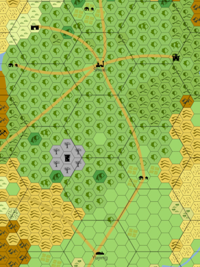
Most of the following applies to making a hex map with any tool or on paper. But we’re focusing on Worldographer and using its child maps/map levels feature. That feature allows multiple map levels where one map or level is designed to show a kingdom, a second with a larger scale shows continents, and a third is the full world.
One thing Worldographer doesn’t do is enforce or even suggest a scale when making your fantasy hex map. On any map though (using Worldographer or not) it is up to you to set the scale that you’d like. And deciding the scale is best served by thinking about the purpose of your map.
Note: You can also watch a video on the same topic making roughly the same points.
Province Maps: 1 Mile/Hex
People can be quite set on their preferences for scaling a map when you get above 1 mile/hex which is typical for a province map. (Reminder for our non-American friends: 1 mile is about 1.6 km. So 6 miles is a little less than 10km–9.6 to be more precise.) For some purposes, such as mapping out a small province or the travel between locations of a single adventure, a 1 mile/hex map makes good sense. But often this is more detail than we want. For example, Pennsylvania is about roughly 283 miles across by 170 miles (46,000 square miles or so). For Europeans, Britain (the island) is almost double that.
While a 283 hex by 170 hex map is well within Worldographer’s capabilities on even older machines, you wouldn’t want to print that on a single sheet of paper (letter or A4 for non-Americans). So often you’ll want to make a map at a larger scale for more purposes.
Kingdom Scale Maps: 5 vs. 6 vs. 8 Miles/Hex
(Note: Here we’re taking a bottom up approach to decide on the scale. Choices we make at this scale impact the higher levels. You may want to think top-down, in which case look at the other sections of this article before making a final Kingdom map scale decision.)
For a typical fantasy kingdom scale map 5, 6, & 8 miles per hex seem to be common. Any of these should fit for the purpose of a kingdom map.
6 Mile Hex Arguments
Some folks like the 6 mile hex because they say on Earth we can see about 3 miles to the horizon. Of course elevation and the size of the planet affect that. So from the hex’s center you can see the rest of that hex’s area. Another reason to choose 6 miles per hex is that people generally walk up to 3 miles an hour if the terrain is easy. So the party can traverse one hex per 2 hours of walking.
5 Mile Hex Reasoning
On the other hand, trails aren’t straight so you may want to round that “up to 3 miles an hour” down, even for easy terrain. This would lead you to a hex that is 5 miles across with the party walking across one such hex every 2 hours.
8 Mile Hex Rationalization
Others argue for an 8 mile hex because the party can walk 3 such hexes per day in easy terrain, 2 hexes/day through simple brush, and 1 hex/day through difficult terrain.
Other Options
You could also argue for a 10 mile hex using the same arguments as the 5 mile hex, but it takes 4 hours to traverse a hex as long as there is no difficult terrain. This option helps if the map would be too “busy” looking at 5 miles per hex.
There’s no wrong scale to pick. It all comes down to your assumptions & map’s purpose.
So a 5, 6, 8 or 10 miles/hex map is a good choice for a small or medium kingdom map. Where do we go from there?
Continent Scale Maps
For a larger empire or a typical continent, even 5, 6, or 8 miles per hex could lead to a map that is several hundred or larger hexes per side. The distance from Boston to Seattle is a little less than 2500 miles (4000 km). So even at 8 miles per hex, we would make a map that is 300 hexes on the long side, and not much smaller on the other side.
When making a continent level fantasy map, many folks go with scales that are 24, 25, 30, or even 32 miles per hex. This is often a consideration of the distance a horse can travel in a day. Various websites say a healthy horse can go 25-35 miles per day. When you consider (as mentioned above for walking) that trails aren’t straight, erring on the lower end is wise. For this longer distance travel the PCs/horses are likely on roads or well-used trails so we don’t have to cut the travel distance often due to difficult terrain. But some mountains may be impassable on horseback . Swamps or heavy jungle might only allow half a hex’s travel per day.
How Kingdom Scale Affects a Continent Map’s Scale
Another aspect to consider for this scale is what did you choose for the Kingdom scale? You’re going to want to pick a multiple of that scale so that the Continent hex can be evenly divided. For example, if you have a 5 mile hex at the kingdom level, you’ll want a 25 or 30 mile hex at this level. But 24 miles per hex wouldn’t be a good choice. But for a six mile kingdom hex, picking 24 or 30 at this scale is a good idea. For an 8 mile Kingdom hex 24 or 32 miles per continent hex would be good choices.
But a third factor is the print size. Even at 30 miles per hex, printing a map of the US would have nearly 100 hexes on a side. That’s OK if you’re printing for a poster (or splitting it across multiple pages as Worldographer’s Export to PDF will do, then taping it together) but that will be busy and hard to read shrunk down on one sheet of letter or A4 paper. So you may want to double the scale to 50 or 60 miles per hex and note that the party can only ride half a hex per day. Or plan to not print it or only print poster-size or across multiple pages.
World Scale Hex Maps
For world scale maps, our two main factors to decide the scale are:
- What is the Continent scale? (Or if it hasn’t been decided yet, we need to consider how the likely Continent scale choices would affect the world scale. And that decision is affecting by the Kingdom scale choice.)
- Do we want to limit how many hexes wide or tall is the map because we’re trying to keep it legible when printed?
So if I’ve picked 50 miles/hex for my Continent Scale, I might pick 250 miles/hex at this scale (a 5:1 ratio). For a earth-world sized map, that would end up with about 100 hexes on the longer side. As mentioned above, on letter or A4 paper that may be too busy so I’d likely double it and make each hex 500 miles (a 10:1 ratio). On the other hand, If I want to keep my ratio smaller at 5 to 1, I could just plan to only use the map digitally, print poster-sized, or span multiple pages and paste it together.
Don’t forget the Staggered Nature of Hexes and Hex Maps
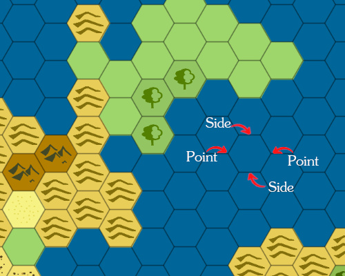
Did you notice the “about 100 hexes on the longer side” and similar statements above? Well, generally we’re stating the distance from flat side to flat side across the hex. But when you measure from point to point across the hex, the distance is actually 1.1547005 times that amount. So our 8 mile hex if measured side to side is over 9 miles point to point.
But when we have the hexes lined up into neat columns, the next column starts 30% before the end of the prior column. So that extra 15% in side-to-side width is more than made up for by this overlap. Therefore to be a little more accurate, we should consider that distances across columns need to be increased about 15%.
If our hex map’s rows line up then this same concept is true in the other dimension.
We also have half a hex added to the number of rows with our columns line up, and vice versa.
And Projections Muck This Up More!
For world and continent scale maps, you also have to remember that the map’s projection also impacts the scale. If your world is a sphere and you’re representing it as a simple flat projection, the distances near the poles will be very skewed. As stated above, the earth’s circumference at the equator is about 24,900 miles. But at 45 degrees latitude (North or South) it is only 17,638 miles. 45 degrees North latitude runs through the middle of Maine and just south of Milan, Italy.
So our map that has a scale of 250 miles per hex at the equator will have a larger scale as we get further from the poles. At 60 degrees north and south latitude it will be double the scale at the equator.
Other map projections make this less pronounced, but unless it is on a globe the scale will still vary. Even a globe can be skewed because the earth is slightly oblong–wider than it is tall.
How Accurate Does The Map Need To Be?
Finally, keep in mind when making your maps you don’t need to be 100% accurate. Old maps weren’t precise even when we had circumnavigated the globe. You can leave a large portion of the world map (or even parts of the Continental map) unexplored. Put “Here be Dragons” and such in those areas. For a fantasy map, that may even be true!
But even if you do have a world or continent map that is fully detailed & filled in, there’s nothing stopping you from changing it later. You can argue that the explorer who reported on that was unreliable. Or it was based on a copy of a copy of a copy. Perhaps it was the best guess of several other maps and much of that guess was wrong. Or even a catastrophe (natural disaster, magic experiment gone awry, etc.) caused a major change. The map issue might be the source of an adventure in and of itself: Why is it so different? What was the cause of the magic explosion?